Showing posts with label Banghwa-dong. Show all posts

Tuesday, May 05, 2015

RASKB Excursion to Yangcheon Hyanggyo and Gaehwasan next Sunday, May 10

Next Sunday, May 10, I'll be leading a walk around the area of Yangcheon Hyanggyo Station and Gaehwasan Station for the Royal Asiatic Society. The former location was the seat of Yangcheon Hyeon, or prefecture, during the Joseon period and still sports the only remaining Hyanggyo, or Confucian Shrine, in Seoul, as well as a number of other historic landmarks. We will also visit a museum to the innovative Joseon Era landscape painter Jeong Seon (1676–1759), and look at paintings of the area that he made in the mid-1700s. I've mentioned the area before (here and here), and this post at Seoul Suburban covers some of the spots we'll visit.


(Yangcheon District in the 1870s)

From there we will take the subway to Banghwa Station to explore Mt. Gaehwasan. After passing through a park with a number of 400-year-old zelkova and gingko trees, we'll head up the mountain to see the numerous tombs, many with beautifully carved tombstones and flanked by stone civic official statues, of the Pungsan Shim clan, who for several generations served the Joseon kings and were memorialized for their meritorious deeds – one of which was taking part in the overthrow of the notorious king, Yonsan-gun.


We will also go to Yaksasa Temple and see a statue of the Buddha and a three-story stone pagoda which date back to the Goryeo Era.


We'll see an even larger such statue dating from the early Joseon period outside Mitasa Temple, on the other side of the mountain. The statue was found buried in the 1930s, when the temple was rebuilt. Both temples were destroyed during the Korean War, but the pagoda and statues survived.


Next to Mitasa is the Memorial to the Loyal Dead, which was erected to remember the 1,100 soldiers of the Korean 1st Army Division who died defending Mt. Gaehwasan - which overlooks Gimpo Airport - during the opening of the Korean War, which will provide an opportunity to learn more about the fighting which took place on the mountain during the war, as well as its military importance in the present. I'll also touch on the importance of the area during the Imjin War.


Being a mountain, of course, there will be lots of opportunities to take in views of the Han River and surrounding area and enjoy what nature has to offer.


If you feel like joining us, please do! The cost of the tour is W20,000 for RAS members and W25,000 for non-members. The excursion will set off next Sunday, May 10, at 1:00 pm from exit 3 of Yangcheon Hyanggyo Station (양천향교) #906 (subway line number 9). For more information, see here.

Friday, May 30, 2014

The first phase of the Magok development nears completion

Back in 2009, just before Line 9 opened, I made a visit to Magongnaru Station; here's a short video of the visit:


This station finally opened last weekend, five years later. I decided to disembark from the train here yesterday evening to see how it looks. And to be honest... not very different at all.

Here's one view in 2009:


And here it is yesterday (the glass panels at right above have been removed):


2009:
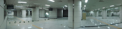
Yesterday (the gates are now installed, as is a convenience store):


That must be an interesting covenience store to work at, since there are almost no people getting off at the moment, though that will change over the next month or two when people start moving into the thousands of apartments that have been constructed over the past three years, which can be seen in the top right corner and center bottom section of this Google Maps satellite photo:


There are still more apartments to be built in the bottom right corner, as can be seen below, though the rest of the development will include research and development facilities. As well, the Gimpo Airport Emart, the immigration office in Mok-dong, and Gangseo district office will move here.


You might notice in the satellite photo above a large body of water. That was originally part of the Han River Renaissance Plan developed by former mayor Oh Se-hoon, before he blundered his way out of his job. The Magok development was to receive a lagoon connected to the Han River (by tunneling the Olympic Expressway under a water channel) as well as a lake park.


As the Renaissance Plan began to tank, the lagoon suddenly was reduced to a lake park:


A real estate agent showed me plans last October which made clear the plan had changed yet again, this time to a Botanical Park, with much of the water disappearing, allowing more room for buildings:


Also, ironically, in the station name 'Magongnaru,' the 'naru' part means 'port' or 'mooring' (for example, Yeouinaru), but now that the connection to the river is never to be constructed, the name is rather... incorrect. One wonders if it will ever be changed, or if it will stand as a testament to big development plans which were never realized.

I'm glad there's still some water, but there were also supposed to be canals throughout the Magok area (see below), but those have been turned into park space instead.


As for the construction of the apartments, I'm curious to see if the surrounding infrastructure will be ready in the next couple of weeks. Sidewalks still need to go in, roads still need to be paved, trees are still being put into park space (though most facilities within each apartment complex seem almost ready), but construction crews were quite busy yesterday, so I wouldn't be surprised if it looks ready in a week or two.


From the building on the left I took these photos last summer, including this one looking north (replacing this neighbourhood)...


... and this one looking south (or to the right two photos above):


The Magok area has had lots of construction going on in it for years now, with the construction of Line 9 and the AREX line taking place throughout it. The area used to have far more interesting neighbourhoods nearby, such as this one, which disappeared to make way for the Magok development.


Needless to say, up until five or six years ago, the area used to be far more scenic; for some reason I preferred these summer and fall views...
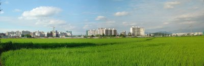


... to this one taken in about the same spot yesterday:


Likewise, I preferred this spring view...
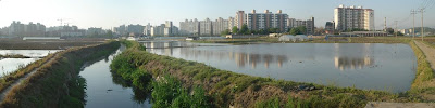

... to this one taken yesterday (you can make out the same apartments in the distance, and the open space you see is the same open space at the right in this photo):


There are some benefits, however. In the photo below is another complex beginning construction on the right, while at left are two finished complexes as well as a new building that the nearby Gonghang Elementary School will move into, replacing the 30-year-old building 200 meters away (the demolition of which will allow another apartment complex to be built). A friend who works at the school is looking forward to working in the new school.


Still, I miss bike rides though the Magok that once was...

Wednesday, May 14, 2014

Walk around Yancheon Hyanggyo and Mt. Gaehwasan this Saturday

This Saturday I'll be leading a walk around the area of Yangcheon Hyanggyo Station and Gaehwasan Station for the Royal Asiatic Society. The former location was the seat of Yangcheon Hyeon, or district, during the Joseon period and still sports the only remaining Hyanggyo, or Confucian Shrine, in Seoul, as well as a number of other historic landmarks and a museum to the innovative Joseon Era landscape painter Jeong Seon (1676–1759). I've mentioned the area before (here and here), and this post at Seoul Suburban covers many of the spots we'll visit.


(Yangcheon District in the 1870s)

From there we will take the subway to Banghwa Station to explore Mt. Gaehwasan. After passing through a park with a number of 400-year-old zelkova and gingko trees, we'll head up the mountain to see the numerous tombs, flanked by stone statues, of the Pungsan Shim clan, who for several generations served the Joseon kings and were memorialized for their meritorious deeds. 


We will also go to Yaksasa Temple and see a statue of the Buddha and a three-story stone pagoda which date back to the Goryeo Era.


We'll see an even larger such statue dating from the early Joseon period outside Mitasa Temple, on the other side of the mountain. The statue was found buried in the 1930s, when the temple was rebuilt. Both temples were destroyed during the war, but the pagoda and statues survived.


Next to Mitasa is the Memorial to the Loyal Dead, which was erected to remember the 1,100 soldiers of the Korean 1st Army Division who died defending Mt. Gaehwasan - which overlooks Gimpo Airport - during the opening of the Korean War, which will provide an opportunity to learn more about the fighting which took place on the mountain during the war, as well as its military importance in the present.


Being a mountain, of course, there will be lots of opportunities to take in views of the Han River and surrounding area and enjoy what nature has to offer.


If you feel like joining us, please do! The cost of the tour is W20,000 for RAS members and W25,000 for non-members. The excursion will set off this Saturday, May 17 at 1:00 pm from exit 3 of Yangcheon Hyanggyo Station (양천향교) #906 (subway line number 9). For more information, see here.

Wednesday, December 11, 2013

Snowfall

It was nice to finally get some snow today that stuck around (for most of the day, at least).


The kids were certainly having fun today...


Wednesday, August 07, 2013

Chihyeonsan Tunnel

As mentioned in the last post, about the construction accident at the Banghwa Bridge last Tuesday, the section of ramp which overturned was set to be connected to a tunnel running through Chihyeonsan. Here is the bridge before construction began in the fall of 2007:


Compare this to around three years later as access ramps were under construction (first posted here):


I took photos of retaining walls being built on the Banghwa-dong side during the spring of 2007:


By early 2009, less than two years later, the walls were done and the tunnels appeared to be as well:


Perhaps they were, but a concrete extension needed to be built (photo taken February 2012):


The same view from last Thursday;You might note the pavilion added at the edge of the forest:


A number of new paths have been built along the side of the mountain as well, likely part of the general efforts of the district to improve trails and amenities and expand park space over the past few years.


We can compare the view from the top of the tunnel between May 2007...


... and February2012:


A friend and I walked through the tunnels during that visit:


The service tunnel connecting the two tunnels; the western tunnel is lower than the eastern tunnel for most of its length:


Here is the concrete base for the steel ramp section which connects to the Olympic Expressway (on ramp) and eventually to the Banghwa Bridge, the arch of which is visible in the background. Does anyone else think the concrete base above is tilted? (Note that the streetlamps are upright, so it's not due to me tilting the camera.) It would have been a base like this, I think, which the ramp that fell was connected to.

Here's the accident site (over on the right) on the north side of Chihyeonsan before the tunnels even began construction.


Seven years after construction began, it'll be awhile before the tunnels ever see traffic (it was supposed to be finished next summer). This accident will slow things further, though I do hope they find out (or, at least, are allowed to share to the public) what happened that day.