
Located in Seoul's Gangseo-gu, Magok district is to get an environmentally friendly makeover with a new name (Eco Energy Town of the Future). The district is to transform into an energy efficient zone that'll boast some of the world's best technology."Some of the world's best technology" is a phrase that has got to win a prize for its meaninglessness. The article talks about how new heating and air conditioning systems will reduce fuel and energy consumption by 50% and recycle 40% of the area's energy. Still, I have to laugh at the first sentence, because if there's an area in Seoul that doesn't need "an environmentally friendly makeover," it's Magok-dong:


Above you can see the same area in winter, spring, and summer. Magok-dong is the last large piece of undeveloped land in Seoul, and at the moment there are about three square kilometers left to develop. What this article doesn't mention, oddly was that the same day it was published, judges were choosing the final design for a lake park in Magok-dong that will be a part of the Han River Renaissance Project, which was unveiled a year ago:

A Hankyoreh article looked at the announcement:
Mayor Oh Se-hoon on Tuesday announced a long-term masterplan to transform Seoul into an attractive waterfront city with high-level tourist and transportation facilities. "The Han River is the last place in Seoul without proper development," Oh said in a press briefing. "I will redevelop Seoul into a pleasant and attractive waterfront city centered around the Han River under the 'Han River Renaissance project.'"
 Magok, Sangam, Danginni, Yeouido, Yongsan, Heukseok, Jamsil
There's apparently more to the plan than what can be seen above; this map shows that every riverside district (gu) is to get some sort of makeover along the waterfront. This page shows renderings of some of the different proposed redeveloped parks.
The idea of a make-over for the areas along the Han River was already in place before the 'Renaissance Plan', as this September 2006 article shows:
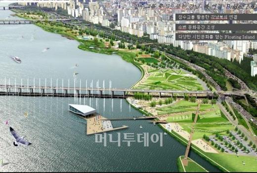
The Jamsu Bridge, on the central section of the Han River, will become a pedestrian walkway from the later half of next year, the Seoul Metropolitan Government said yesterday. The change is part of a five-year, 253 billion won ($267 million) urban development plan, which focuses on adding more open space and strengthening the leisure infrastructure along the Han River, which is known chiefly for its crude, concrete embankments and jungles of cookie-cutter buildings.The redesigned Jamsu Bridge (complete with fountains), as well the park south of the bridge, can be seen in this earlier rendering linked to above. As you can see, a man-made island existed in this plan. In late March of this year, an announcement was made that three islands would be built in the same area.
According to the plans, the city will spend 3.6 billion won to redesign the Jamsu Bridge, which is the lower half of the double-decked Banpo Bridge, as a pedestrian only bridge. Jogging courses and bicycle lanes will also be added. A 2,500 square-meter public park will be built at the southern side of the Jamsu Bridge, equipped with playgrounds and a water garden.
Aside from the Jamsu Bridge, city authorities are planning changes to five other bridges to make crossing easier for pedestrians. Through the end of 2008, the city government plans to remove one car lane from the Yanghwa, Mapo, Hangang, Dongjak and Hannam bridges and convert them into walkways. To improve accessibility, the city will rearrange bus lanes to establish 14 bus stops on each side of the five bridges.

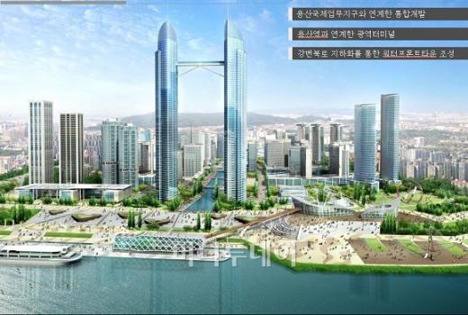
Floating Island will be built on Hangang near Banpo, the Seoul Metropolitan Government announced March 28. When completed in September 2009, the Floating Island, composed of three artificial islands, will have facilities for performances and exhibitions as well as festivals and sports and leisure activities. Floating Island boasting an eco-friendly design will be a new Seoul landmark, according to the City. Together with the renovated Jamsu Bridge and Jamsu Fountain, this area will become a tourist destination, the City said.The islands will be connected to the park and to the Jamsu bridge and lit up with LED lights. The first rendering seen here is a plan for Yongsan, which includes a very tall tower and a canal (to be built on the Korail rail yards near Yongsan station). It's since been redesigned (and will be again, because five architectural firms are competing to design the project, which will be finished in 2016):

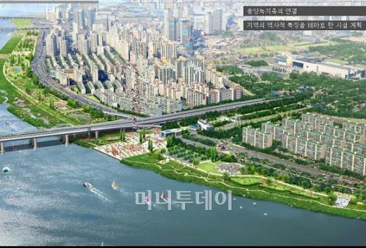
Approval has been given to a new super tall skyscraper in Seoul, South Korea. The project which has been undertaken by the Korean Rail Corp will upon completion stand at a healthy 615 metres which would make it the second tallest in the world, after Burj Dubai which standing at 830 metres holds the title at least for now.Read the whole article for more information. Worth noting is that the proposed waterfront park in Ichon-dong is, according to the map below, to have green corridors connecting it to the proposed park to be built in Yongsan after the US military leaves the Yongsan base. Note that at the top, Yongsan park is to have a corridor linking it to Namsan.
The 150 storey tower will be centre-piece in a new international business district which will be close to Yongsan station which is already a central hub for transport with railroads, train depots, a train maintenance centre, logistics centres and a postal office already located there.[...]
If the project is realised, work is expected to start on the tower 2011 and should be completed by 2016. Whether this happens is another thing entirely as South Korea has an almost one hundred percent record of proposing super-tall towers that never get built.

To the north, as we see here, the Seun Sangga redevelopment is supposed to provide a green axis (below, center) linking Jongmyo (and the palaces and mountains to the North) to Namsan.

 Phase 1 of the Seun Sangga Plan
If these plans come to pass (in 15-20 years, I mean!), there will be a green link connecting Jongmyo to and Changgyeongung to the Han River. Of course, the city government has other links in mind for the Han River Renaissance Project.
The most ambitious of the 33 sub-plans of the masterplan calls for restoring the waterway linking the river to the West Sea. Oh said international freight and passenger ships could reach the Chinese port cities of Shanghai, Tianjin and Qingdao from the river if the waterway reopens.For the curious, the incomplete Seoul-Incheon canal runs along the Incheon Airport expressway, and can be seen on Google Maps. It will open onto the Han River north of Gimpo Airport, near where I live. Speaking of where I live, the one Han River Renaissance Project that is to be nearby is, of course, the Magok Waterfront Project. Here is an early rendering of the plan:
There are two ways to link Seoul with the West Sea: One is to follow the natural flow of the river that joins the sea in areas just north of Ganghwa Island. The other is to use 20 kilometers of the "Gyeongin Canal" now under construction to link Seoul with the western port city of Incheon. The construction of the Gyeongin Canal has been suspended since 2003 because of opposition from environmentalists and civic activists.
Seoul also plans to build an international terminal either in Yongsan or Yeouido and excavate the river bottom to create a depth of four meters in the river's main stream. "We believe either way would be possible with cooperation from the central government," he said. "If Seoul becomes an international port city, it would reduce transportation costs and attract more foreign tourists," he said.

Thankfully, this plan did not come to pass, as in November last year, the city created an open competition for designs of the Magok waterfront, which can be seen in a pdf here. I first found out about the competition when Cosma, an architect from Naples, contacted me to ask questions about the Magok area since he had read my blog posts about Magok. I got to meet with him when he came to Korea a few months ago, and had an interesting conversation with him. Unfortunately, his project wasn't chosen, but I wish him best of luck in the future.
Here is the site, as seen in the context of its surroundings.

I've added outlines of other developments in the area - the (almost finished) Balsan Development, the Banghwa New Town, and the proposed Hwagok and Mok-dong New Towns. Give the area 20 years and its only dwellings will be apartment buildings. How thrilling. Here's a closer view of the site:

It was only when I saw this map that I realized they were going to remove part of the sewage treatment plant to make room for the park. Where it says 'Han River', the piles for the Incheon Airport Railway bridge can be seen. Here's a photo of the bridge taken last year from Mt. Gung, where the 600 year old Yangcheon Hyanggyo can be found.

More photos of the construction of the Incheon Airport Line in Magok-dong can be seen here. The pdf I linked to above describes the intention of the Magok Waterfront Project:
Magok is one of six proposed specialized waterfront areas comprising the Han River Renaissance Project, which is considered a priority project of Seoul. The Project aims to transform the overall landscape of the Seoul area by focusing on the development of six special waterfront areas along the Han River, which flows across the heart of the city. As the first of the six, the Magok Waterfront will play an important and symbolic role. The size of the Site of the Waterfront is approximately 1,170,780 square meters.It also describes how the plans for Magok's development came about:
In 1995, Seoul announced a progressive plan to develop the city’s remaining large scale, undeveloped area, Magok. Under this long-term plan, Magok was to be systemically managed, and development was reserved for a later time so that preparations could be made in advance.The project is to include a lake park and marina opening onto the Han River. Below you can see the Incheon International Airport Railroad (AREX) in yellow and Line 9 in green. The new Magok station will have exits opening onto the site. The blue lines represent the streams flowing through the fields and the reservoir that sits in front of a pump house which faces the Olympic Expressway (for drainage during floods). As for the expressway (and Yangcheon Gil) decisions had to be made whether to create bridges or tunnels to allow the flow of water (or boats, really) into the marina.
Large scale development projects such as the Balsan Residential Area Development Project, the Banghwa New Town Development Project, the Gimpo Airport Comprehensive Development Project, and the construction of Subway Line No. 9 and the Incheon International Airport Railroad, are currently underway within and around Magok. Due to these rapid changes, there has been growing concern over excessive development of the surrounding areas and the need for systematic management.

There's actually an historical property I knew nothing about within the site, even though I'd seen it many times. It's marked above as the "old pump house."
The former Yangcheon Water Supply Association Drain Pump Station was constructed in the early 20th century.[...] The old drain pump station is drainage facility of the early 20th century that is a registered cultural asset located within the Site. The old drain pump station is highly valued as a modern industrial historical asset. It is a modern structure and the only agriculture related industrial structure in Seoul. The old drain pump station is not currently used for any drainage functions but is used for the repairs of heavy equipment.Here's what it looked like in the colonial era:

Here's what it looks like now:

If you continue through the bridge seen at left, you arrive at the reservoir, seen below. The bridge (where Yangcheon Gil passes over the stream) is seen at right, and off in the distance at left is the new pump house. The area below is normally swimming (?) with ducks.

The new pump house abuts the Olympic Expressway.

On June 24, the winner of the contest was announced:

The winning project was Kim Gwan-jung's "Heart of Magok is Nature of Living Water". I don't have access to any large images of the plans, but it appears the diagonal raised area will cover much of the existing stream (and perhaps feed it into the reservoir, which still seems to exist in the plan above (though I see no indication of where a new pump house will be). The raised area also separates the marina from the lake park and also likely covers large parts of both AREX and Line 9. It also has chosen tunnels for the expressway and street. I don't see how cyclists and rollerbladers are supposed to deal with the breach in the Han River Park, however.

I'm not exactly sure what the pools at bottom right are supposed to be, as in other renderings they seem to be surrounded by vegetation. I haven't seen many other entries ( a few are here), but I'm pleasantly surprised by the choice made here, because it appears to be very water and nature oriented (though who knows what SH Construction will add when they build it), in stark contrast to the original rendering that accompanied the announcement:
Here are some other images of the winning project:

Will the lake park have swimming pools set out in the middle? That's what it looks like above, but it's hard to be sure. Here's the southern half of the plan:

Construction is to start in July next year and finish in June of 2013. This should make for a nice addition to the area, so I'm thankful for the Han River Renaissance Project, because I don't know if the city would have considered removing a large chunk of the sewage treatment plant to make way for a project this big otherwise. The local paper (Gangseo Magpie News) mentions that canals are going to be made linking the lake park with the rest of Magok-dong. Of course, it'll be 20 to 30 years before all of Magok is developed.
3 comments:
For all my puttering about looking for connections between contemporary Korea and foreign SF, I have to say: that image #7 in your post looks like something copied straight off the cover of an old SF pulp mag. Except the silvery "teardrop tower" in the middle would be a rocket ship beside which a buxom blonde would be standing. Uncanny...
Nice post. Icheon-dong should be Ichon-dong. I live in Icheon, Gyeonggi-do and the sounds are different.
-mashimaro
you have contributed a great perspective on the 'Renaissance Plan'. Thank you very much for the valuable information! In Seoul there is a small but perceptible gap between 'image' and 'reality' and that is especially notable when we compare digital simulations of 'the future' with real effects, on the ground so to speak. Thanks again, and cheers. Primalamerica posts...
Post a Comment